

Stormwater
Stormwater
The Draft 2024-2025 MS4 Annual Report can be viewed at the below link. Comments can be provided to craigb@queensbury.net.
TOWN QBY DRAFT MS4 Annual Report and Interim Progress 02.19.2025
The Town of Queensbury Stormwater Management Program Plan ( SWMP ) is slated to be revised to be current with the NYS DEC SPDES Program requirements. The 2024 Town SWMP can be viewed at the below link and the proposed revisions are also available. Comments can be provided to craigb@queensbury.net
2024 FINAL Town of Qby SWMP Plan
Qby MS4 SWMP Plan Updates 2025
Big Thank You to all those that helped out during our Stream Cleanup day at Hovey Pond Park 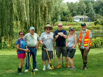
Town of Queensbury MS4 Stormwater Management Program Plan
MS4 Program
In Warren County, the Town of Queensbury is a regulated municipality under the NYS Department of Environmental Conservation (DEC) Municipal Separate Storm Sewer System (MS4) Program. All municipalities regulated under the MS4 program are required to implement Best Management Practices (BMPs) to control stormwater runoff. The purpose of these regulations is to help protect and improve the quality of public waterbodies in more densely populated areas of the state. These regulations outline a large number of tasks (formatted as six “minimum measure”) which the municipality must undertake to be in compliance with these mandates.
The six minimum measures which the Town of Queensbury must undertake consist of the following:
MM1: Public education and outreach
MM2: Public involvement and participation
MM3: Illicit discharge detection and elimination
MM4: Construction site runoff control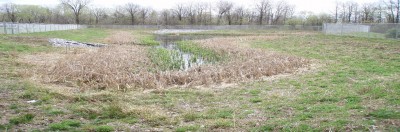
MM5: Post construction stormwater management
MM6: Pollution prevention and good housekeeping for municipal operations
For more information about BMPs for MS4s, Visit:
U.S. Environmental Protection Agency or NYS DEC MS4 Information
Stormwater Runoff
A significant concern in any developed area is stormwater runoff impact of the nearby waterbodies. Along roadways and parking lots, runoff is often channeled into drains and pipes, which often outlet into a stream or a lake. Impervious surfaces such as roads, rooftops and asphalt parking areas do not allow water from precipitation or snowmelt to infiltrate into the ground. As the water flows across these impervious surfaces, it can collect sediment, phosphorus, de-icing materials (sand and salt), petrochemicals and other pollutants.
Roadside ditches also contribute to stormwater runoff issues when improperly installed or poorly maintained. A poor roadside ditch can contribute to increased stormwater runoff velocity leading to increased erosion and sedimentation. During warmer months, runoff can also be significantly warmer than the stream’s water, causing thermal pollution affecting the stream’s aquatic communities.
These stormwater discharges are a major contributor to sedimentation/delta formation issues in the lake, and can also have significant negative impacts to a stream’s aquatic community.
Calcium from road salt (if calcium chloride is used as a de-icing agent) can create habitats at the mouths of streams suitable towards zebra mussel colonization. Phosphorus transportation by sediments may create multiple problems including the eutrophication of waterbodies, causing reductions in water quality and habitat for aquatic plants and animals.
As land gets developed, typically more water runs off the land into nearby streams, often very quickly following a precipitation event. This large volume of water entering a stream in a short period of time can cause an overwidening of the stream channel in order to accommodate the increased volume of water. These channel widening processes occur through accelerated streambank erosion, and ultimately more downstream deposition (deltas).
Project Updates
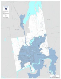
Click here or on above image for map view
Currently one of our main focuses for the Town of Queensbury MS4 program is storm sewer mapping and data collection within the MS4 boundaries (see right map). All of the storm sewer data and GPS locations are converted into shapefiles and mapped in ArcGIS software.
Educational References
Public Education and Outreach on Stormwater
Public Involvement/Participation
Water Conservation
Rain Garden
Managing Stormwater Runoff Using Green Infrastructure
Managing Rainwater
The Solution to Stormwater Pollution
Make Your Home the Solution to Stormwater Pollution
Warren County Soil and Water Conservation District
Illicit Discharge References
Illicit Discharge Detection and Elimination
Construction References
Construction Site Stormwater Runoff Control
Post-Construction Stormwater Management
Pollution Prevention References
Detecting Failing Septic Systems on Your Lake
Pollution Prevention/Good Housekeeping for Municipal Operations